Image is Sourced from NDTC
Written for Siachen.com by Raj Narayan Nyayapathi,
Resident of Hyderabad, Telangana State.
Introduction
The article that follows is an effort to have an exhaustive study of Siachen Glacier and why it is important to India. The attempt here is not only to discuss the risks of war that the soldier faces but it details out the war against weather and nature. Siachen is also an interesting hub for adventure lovers, mountaineers, and tourists.
Relations between India and Pakistan has always been on thin ice ever since their independence. Siachen, the highest battlefield, has been an arena where the maximum clashes occur.
Immediately after taking charge India’s new defence minister Rajnath Singh visited Siachen on June 3rd, 2019. This has kindled a new wave of interest. What will be the Government’s strategy? It is a wait and watch situation about how the Government would want to restore peace in the region.
Table of Contents
The geography:
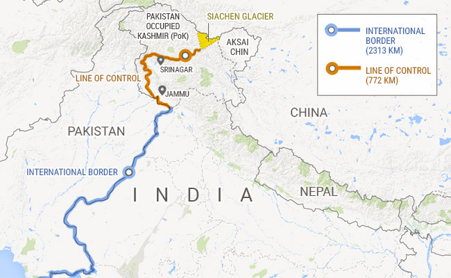
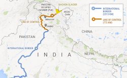
Located close to the Indo-Pak Line of Control (LOC), Siachen Glacier is at an elevation of approximately 18, 875 feet (5,753 m) above the sea level. With a length of around 76 km, Siachen is the second longest glacier in the global non-polar areas. It is one of the largest glaciers in the Karakoram and the longest glacier in the Karakoram Range.
Siachen lies in Northern Ladakh at about approximately 77.1° East, 35.42° North, northeast of the NJ9842 where the LOC ends. Source: https://en.wikipedia.org/wiki/Siachen_Glacier.
Siachen lies in the north-central of Jammu and Kashmir closer to the border of India and Tibet. It is located on the north facing slopes of Karakoram range and the major source of water for the Shaksgam river. It is also called the Muztagh river. The glacier as such lies in a huge trough of more than 2 Km width with boulders and rocks on its two sides.
Because of the frequent fighting between the troops of India and Pakistan, Siachen Glacier is often referred to as the highest battlefield on earth. Siachen is very important for India. So long as it is under their control, they can stop the Pakistan Army from connecting with the Chinese and be a cause of threat to Ladakh. Siachen comes as a shield between Baltistan, occupied by Pakistan and the Shaksgam valley under Chinese control.
Defence Minister’s visit
While it always was a subject that could not be ignored, Siachen has again come to the forefront with Mr. Rajnath Singh’s visit. Continuing with the Government’s no-nonsense policy, as seen in the surgical strikes, Mr. Rajnath applauded the soldiers’ valor and determination. He instructed the commanders to be alert and ready to give a befitting reply in case there were any provocative acts from the other side of the border.
More about the amazing and controversial glacier:
The division of British India saw the formation of two nations India and Pakistan. Relations between the two nations has never been cordial right from the independence time. Some of the reasons for the conflicts have been the river water dispute, Kashmir issue, border disagreement, and so on.
A brief gist:
However, there is more to the history of Siachen. As per the writings of Mr. Harish Kapadia http://www.harishkapadia.com/downloads/history-of-siachen-glacier.pdf, attempts to reach Siachen has been going on for several decades. There are many legendary stories mentioned in the referred article.
The first expedition was made in 1821 by W. Moorcroft who came up to the nose of the glacier and confirmed its existence.
In 1835 G.T. Vigne tried reaching the Bilafond La (on the ancient Silk route between China and India) from the west but could not locate the glacier.
In 1848 Henry Starchy discovered the Siachen glacier and climbed two miles from the snout in the Nubra Valley.
Later in the year, Dr. Thomas Thompson also was successful in reaching the glacier.
E.C. Ryan of Survey of India in 1861 miscalculated the stretch being only of 16 miles.
Sir F. Younghusband in 1889 reached the end of Turkestan (North) and made an estimate the glacier has a long stretch.
In 1907 a map of the Himalayas was published by Sir Sydney Burrard. The glacier was not identified in the map. However, he did indicate the possibility of a glacier existing at the top of Nubra Valley.
In 1909 a combined expedition by Dr. Tom Longstaff, Dr. Arthur Neve, D.G. Oliver and Lt. A.M. Slingsby were able to establish the length of the glacier and location of different passes. Many more mountaineers, explorers followed. The details of them all are mentioned in the above-referred article.
1972 Simla Agreement
The Siachen conflict has its roots linked to the imperfect demarcation of the territory. After Pakistan surrendered in the Indo-Pak war in 1971, an agreement was signed by the Indian prime minister Indira Gandhi and Pakistan Prime minister Z.A Bhutto in 1972 which came to be known as The Shimla Agreement. The 1971 war witnessed a devastating defeat for Pakistan and the formation of Bangladesh.
Indira Gandhi was hailed for her great leadership. People were of the opinion that unfortunately, she did not take advantage of the victory in war. There were around 93,000 prisoners of war with India. Even the military leadership in East Pakistan had surrendered. India also had captured much of Pakistan’s territory and important locations in Kashmir. India took a very considerate stance rather than pressurizing Pakistan.
Most of the conflicts that have taken place at Siachen could have been avoided had India insisted on demarcating the borders. It was the foreign Secretaries to the Indian Government who convinced Mrs. Gandhi to be liberal in her decision.
The peace negotiations in Simla began on the 28th of June 1972 and the talks carried on for 5 days. However, the Siachen area was cast aside saying the land was barren and useless. It is believed the Indian negotiators were keen to reorient Pakistan’s internal politics and eliminate another phase of the cold war. There is also a second opinion that says Bhutto had implored with Mrs. Gandhi to trust him. He pleaded since he did not want to be condemned and attacked by the military officials back home.
About the Siachen dispute:
However, Pakistan did not honor their commitments. Maps showing the Siachen area under Pakistan territory started circulating. Within the next decade from 1972 to 1983 the country allowed several missions, both local and international, on the Siachen Glacier. Pakistan officials accompanied the foreign nationalities that took up the expeditions. They reached many peaks including Singhi Kangri (Mont Rose), Teram Kangri, Apsarasas, Ghent, Saltoro Kangri 1, etc.
Most of the expeditions were taken via Bilafond la, Gyong la, or Sia la to reach the glacier (India took control of them later in 1984). What was a hobby and adventure for the foreigners was thus given a political twist by Pakistan.
India did not stay quiet. They sent three army expeditions. The first one in 1978 reached Teram Kangri. The second expedition was in 1980 when another Army unit ascended on to Apsarasas. The third trip was in 1981 when the Army climbed Saltoro Kangri 1 and many others that came in the route.
Maps in Europe were printed that showed the LoC joined to the Karakoram Pass thus as support to Pakistan’s claim of Siachen being under their control and creating a common border between China and Pakistan.
American maps also had a similar display of Point NJ 9842 joining Karakoram Pass rather than Saltoro ridge towards K2, the second highest peak as had been decided upon, in the 1949 Karachi agreement.
Pakistan played mischief and on 21st August 1983 formally laid claim that the terminal point of LoC at NJ 9842 concluded at Karakorum Pass. Pakistan had earlier in 1963 conceded Shaksgam Valley to China. The latter country had constructed a 70 km metal road in the Shaksgam Valley.
Things were slowly getting out of control when Pakistan had allowed a Japanese expedition to attempt the Rimo Peak in 1984. Rimo peak situated on the east of Siachen overlooks the eastern portion of the Aksai Chin. Had they been successful, the expedition could have created a link between the eastern and western routes- leading to the route between China and Karakoram Pass.
India in control
India swung into action. Indian troops landed on the Bilafond La Pass on the 13th of April 1984. The mission is called Operation Meghdoot (named after the messenger in the famous Sanskrit play” Kalidasa”). This was when the India Air Force and the Kumaon Regiment of Indian Army went to the glacier. The Tricolor was hoisted at Bilafond Le on April 17th, and at Gyong La on 23rd May.
Pakistan troops tried on the 25th April but were unsuccessful because of harsh weather conditions. They ultimately set up a post “Quaid Post” at an altitude of 21,000 feet on June 25th, 1987. This was because Indian troops had run out of ammunition.
The Indian government gave permission to a joint Indo-British expedition in 1985 to ascend Rimo Peak approaching it from the Nubra Valley. Later in 1986, an Indo-American team was successful in reaching the glacier. There was heavy firing from the Pakistan troops where the Indian team climbed Sia Kangri and the American reached Indira Col (West). In 1997, an all-women Indian team led by Bachendri Pai crossed the glacier and reached the India Saddle. It was an exemplary show and made the nation proud.
In 2002, a joint team from Japan and India crossed over Col Italia in the east and arrived at the Teram Shehr Glacier and climbed the 7030m Padmanabh, to the east of the glacier and went on to explore the unexplored Teram Shehr Ice plateau. In 2003, both the countries agreed on a ceasefire.
India has built the world’s highest helipad at Point Sonam which is at a height of 21,000 feet (about 6,400 meters) above the sea level. India has also installed the world’s highest telephone booth at the glacier.
The bigger enemy:
The cease-fire did bring a respite for both the nations. Nevertheless, both countries fight a greater battle against nature. The soldiers here are posted at altitudes ranging from 4,000 to 6,700 meters (13,000 to 22,000 ft). Since the time of cease-fire, death from bullet injuries has been minimal.
Soldiers die because of the freezing temperatures, lack of oxygen, or the frosty weather. They have lost several numbers of personnel due to avalanches, frostbites, and many similar difficulties. Sweat in the body turns to ice and adds to the severity of the cold in their gloves, shoes, etc. The soldiers thaw their machine guns and rifles with hot water
Frostbites are caused due to exposure to extreme cold climate. Avalanche is a snowslide. Huge slabs of snows break into pieces and slide down in slopes. They can occur due to natural forces (like wind drifting, temperature changes, precipitation) or due to human activities like lighting fire for cooking or due to candles.
Some of the past deadly avalanches have claimed lives in both the camps. in April 2012, about 140 soldiers from Pakistan’s Northern Light Infantry were buried. It is said ice and rocks up to 150 ft deep had engulfed the Pakistan army’s headquarters.
Similarly, four years later about ten Indian soldiers were buried by an avalanche in the glacier. Nine of them were found dead. In a rare and miraculous incident, one soldier by name Hanamanthappa Koppad was found alive 6 days later along with the nine dead men by a rescue team. He was immediately rushed to the army hospital in Delhi where he fought a losing battle and died 3 days later.
Conclusion
The stakes are high. There is a lot of investment, the risk to human lives, and resources being spent on the Siachen Glacier. Calls for demilitarization of the glacier are coming from various quarters. Things have improved over the past years. The army now has better equipment, resources, and medical facilities. But there are people who think costs are not too high when it is on the brave soldiers who are fighting both climate and the enemy to save the country.
They deserve more than a salute!